![[Mars Blog]](/images/masthead.gif)
|
|
|
|
March 6-9, 2006
Visit to New Orleans
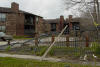
Flooded cars collected under the approaches to the river bridges. The real story emerges... Canal Street appeared pretty normal from above, but had a very different feel to it due to the difference in clientele -- more relief and reconstruction workers, fewer partiers. The formerly-newly-opened Ritz-Carlton undergoing its second facelift in three years thanks to Katrina. A trailer park of FEMA trailers next to the cemetery near Canal and I-10. Not sure if this is storm damage or reconstruction in progress (near Orleans Ave.). The morning sun over Our Lady of the Tarpaulins. Looking out over the Ninth Ward. Lacking time to drive around, most of my pictures are unfortunately taken from I-10, so get used to seeing the railing. More tarps. It was not unusual to see tarps stamped "FEMA", like the printing on the back of Kodak Paper. And it's a good thing, too, that they took the time and spent the money to have their tarps specially marked -- wouldn't want someone else to get the credit. Gutted houses in New Orleans East, near the bottom of the High Rise, ready for reconstruction. The remains of the Frenchman's Wharf apartment complex, another view normally hidden by trees. And to think I decided against renting here because they didn't do enough to keep the boardwalks free of bird poop...it would seem they have more pressing maintenance problems at the moment. (Note the car in the St. Charles Canal on the left.) Gutted townhomes in New Orleans East. When I moved to NOLA in 1997, this place was somewhat dilapidated. Someone put a lot of work into fixing it up in 1999-2000. And now it's back where it started. The shopping center at the Crowder Blvd. interchange, which is normally a bit busier than this. The sign at Lake Forest Mall. For most of the 6+ years I lived in NOLA, the marquee portion of this sign had a hole in it that looked like it had been made by some sort of explosive projectile...but now it's the only remaining portion of the sign besides the posts. I imagine business is good for these guys. This church near the Bullard interchange appears to have lost its ongoing battle to keep its brick wall standing. Schwegmann Plaza at Bullard and I-10, where we often went for lunch (Michoud's VAB is the square patch on the horizon, between the tall sign and the red storefront in the middle of the picture.) For those who have heard the story, the nasty "bird in the deli" incident happened at the grocery store visible behind the Shoney's on the left. I'm not sure what to make of this. The normal bathtub rings can be seen on the signposts near ground level -- but there was one big, wide stain across the sign at an angle, as well. What's left of the east side of Eastover Country Club. A common sight in NOLA these days: a half-height stop sign hung at an intersection where the lights are still out. So much for climate-controlled self-storage. Vucinovich's (another popular lunch place for Michoud employees) is said to be ready to reopen in the next week or two. A FEMA trailer in Village de L'est along Michoud Blvd. I wondered why the trailers here were all elevated so high, and then I noticed where the bathtub rings were...right at the level of the trailers' bottoms. It's hard to tell in this picture, but this neighborhood was a hive of activity. Most of the houses had FEMA trailers out front, a lot of them had been gutted already, and there was already some construction going on. Not so just a little further down the street... A car abandoned along Michoud Blvd. Note the bathtub ring about 6" below the roof. The water was a little deeper near Trappers Ct. More water marks. A ghost-town street in NOE, probably Adventure Ave. That's not a stripe on the van in the driveway. More water marks in the Adventure Ave. neighborhood. Note that the door is not half-red -- that's rust. The remains of Oak Island Apartments, the first place I lived in NOLA. (It used to look nicer than this.) That's my old apartment, second floor, middle of the picture. Nice to know my insistence on a second-floor apartment would have paid off, (aside from damage from the roof leak). The neighborhood across the street appears to be just as abandoned as Oak Island. Hardly any signs of activity in the area...no trailers, no tarps, no debris piles, no people. Just a few port-o-lets in the median. Looking southeast towards Lake Borgne. This used to be a dark and impenetrable swamp forest. A hurricane can wipe out New Orleans, but some things never change...like burned-out joyride cars, piles of old carpet, and abandoned sofas at the end of Michoud Blvd. Demolition. Another brick wall that didn't fare too well. Flood and fire. Probably still figuring out how to stamp them with "FEMA". Near Downman and I-10. I'm surprised there weren't more of these billboards. It's surprising where you find boats in New Orleans these days. This is one of two at Paris Ave. and I-10, but they were all over the place. Markings on a house along Paris Ave. A home near Prentiss and Paris. A friend's home. He put the graffiti on the plywood before evacuating, and -- oddly enough -- ended up in Denver. Ghost town. This is a couple blocks from the London Ave. Canal break, and was under 8-9ft of water. This is the London Avenue Canal, but I'm not sure if this is actually the break itself. An unwanted port-o-let in Spanish Fort. Office on the corner of West End Blvd. and Robert E. Lee. I always seemed to end up stopped at the light, staring at this place, while running late to volleyball. Looking over the levee at what used to be Coconut Beach. The structure on the left is a floodwall on the levee with a retractable floodgate for the street. To the left of the battered semi trailer in the middle of the picture used to be a long open-air bar, of which no trace remains. The open plot of land contained about twenty beach volleyball courts. Just outside the levee. The cranes are working on the break in the 17th Street Canal, of which the green berm is one side. The break is actually a short distance out of frame to the left. The tower in the distance is the Doubletree Hotel at the end of the Causeway in Metairie. A pile of boats in West End Park. There was less damage to the marina and houseboats than I would have expected, considering what happened to Jaeger's and the Dock. Pilings are all that's left of Jaeger's and the Dock, two large restaurants/bars which were torn apart and dumped onto the volleyball courts about 500ft away. Looking back at Coconut Beach from in front of the Dock. Looking down the 17th Street Canal from where it empties into Lake Pontchartrain. The dark red band just below the more distant crane on the left is the steel wall blocking off the canal near the break. There used to be a couple more restaurants on the pilings in the foreground.

Flooded cars collected under the approaches to the river bridges. |